Frequently Asked Questions
Based on federal and state law, municipalities must abide by the following criteria (listed in order of priority)
- Equal population as required by the U.S. Constitution
- Compliance with the Federal Voting Rights Act
- Contiguous
- Avoid divisions of communities and neighborhoods to the extent practicable
- Follow easily recognized boundaries such as major roads and railroads
- Be compact
The adopted map follows all of these criteria in the required priority order. Neighborhoods and communities of interest are kept undivided as much as practicable after compliance with the criteria designated as higher-priority by federal and state law, as detailed in the following district by district descriptions:
- In the south, District 5’s boundaries are defined by the railroad tracks, 3rd Street, Wheeler Avenue, Foothill Boulevard and the 210 Freeway. The only District 5 border that some might not consider an “easily recognized border” is the two blocks of E Street, but following E Street kept the University of La Verne, a noted community of interest, united.
- District 1 shares much of that border with District 5, following the same roads and railroads. On the other side of District 1, most of the border is the widely-recognized D Street and 8th Street bordering Bonita High School. Only along I Street and Grove Street are there three city blocks where the borders may not be widely recognized, as there was no widely recognized option nearby that met population balancing requirements and thus I Street and Grove Street were used as a compact way to finish defining that boundary.
- District 2 follows the same western borders as District 1. On the north side, District 2 had to stop at Amherst Street because of population requirements – going all the way up to the 210 Freeway for the entire length of the border would have put the map out of compliance with federal law. Many of the census blocks on the south side of Amherst Street extend all the way to Foothill Boulevard, so bringing the District 3 border south of Amherst Street would have also involved too many people that would make the map imbalanced. Fruit Street is an easily recognized major road used to step from the freeway to Amherst Street.
- On its southern border, District 3 follows the freeway and Amherst Street, as noted above. The western border of District 3 is Wheeler Avenue, a major road and easily recognized boundary. The northwest boundary of District 3 ideally would have been Marshall Creek, however that would have left District 4 under-populated by 9% and the map out of compliance with federal law. So the houses bordering Marshall Creek on both the south and north sides of the Creek are united in District 3 to meet federal equal population requirements.
- Finally, District 4 is bordered by the easily-recognized boundaries of the 210 Freeway, Foothill Boulevard and Wheeler Avenue, with the rest of the District 4/District 3 border as described above.
In December 2020 and July 2021, the La Verne City Council conducted two study sessions exploring the purpose and process of districting.
With several resident requests and nearby jurisdictions facing legal challenges on the basis of their election systems over the years, the La Verne City Council consulted with Doug Johnson, the President of the National Demographics Corporation, regarding the City’s election system options in December 2020.
At the July 2021 meeting, the Council unanimously adopted Resolution No. 21-47 which, among other things, determined that it:
- Is in the best interest of the City to move from its current at-large electoral system to a by-district election for all five members of the City Council pursuant to California Government Code section 34886 and in furtherance of the purposes of California Voting Rights Act; and
- Begin by working with an experienced demographer to assist the City in establishing maps for a by-district electoral system.
While the City has not yet received any legal challenges to its election system, the Council determined it prudent to initiate the districting process to prevent any costly potential legal challenges and better understand its by-district election system options.
During the same July meeting, the City Council also directed City staff to engage National Demographics Corporation as its demographer to guide the City through the districting process.
The City’s current system is vulnerable to legal challenges. Cities that have been presented with demands for districting have been faced with settling the challenge by paying a minimum of $30,000 and agreeing to go through the districting process to upwards of hundreds of thousands, or even millions, of dollars to fight. By waiting until a legal challenge is presented to the City, the City would face a significantly shorter deadline to go through the districting process than it does before a California Voting Rights Act (CVRA) letter is filed. Pursuing the districting process now is a risk management decision that allows the City to take time to solicit resident feedback on their communities as well as enough time to consider and choose a map.
Additionally, while the City of La Verne is aware of the City of Santa Monica lawsuit challenging its at-large election system, the California Supreme Court’s decision will not come down in time for the June 2022 election. Regardless of the decision, it will not change the state’s law that prohibits racially polarized voting that marginalizes local minority communities. Even if the California Supreme Court rules in favor of the City of Santa Monica, the City of La Verne could still be sued for violation of the CVRA and be forced to district. Furthermore, delaying until the decision in Pico Neighborhood Association and Maria Loya v. City of Santa Monica could jeopardize the legitimacy of the City of La Verne’s June 2022 election results, thereby forcing the City to spend additional funds to undergo another election process. The City Council unanimously decided that exploring the process of districting was the most prudent thing to do considering the significant financial and legal risks associated with remaining with its at-large election system.
National Demographics Corporation (NDC) is a nationally recognized nonpartisan demographic firm that assists local governments throughout the states of California, Arizona and Nevada by guiding their districting and redistricting processes while leaving the final policy decisions to the jurisdiction’s residents, elected leaders and City staff. With over four decades of experience, NDC has successfully completed over 375 projects. Learn more about NDC and their team on the NDC website.
NDC’s contract with the City includes the demographer technical analysis and mapping functions, as well as bilingual communications activities including the development/maintenance of this districting website, weekly social media posts and targeted boosted posts, and press release copywriting and distribution to media contacts and community groups.
Under a district-based election system, the City would be divided into equally populated districts. Under a five-district system, for example, there would be five equally populated districts with a council-appointed rotating mayor. This would mean the five City Council Members pick one Council Member to serve as mayor for one year, after which the City Council picks a different Council Member to serve as mayor for another one-year term. A candidate must reside within an election district and is elected only by voters residing within that same election district.
Currently, the City Council consists of a Mayor and four Council Members who are elected at-large. This means any eligible voter who lives in the City can run for office, and every voter may vote for the Mayor and all four of the City Council Member seats, regardless of where they live in the City. The Mayor serves a two-year term and Council Members each serve four-year terms of office.
Under the City’s form of government and municipal code, all five elected positions (4-Council Member and Mayor) possess the same voting power. While mayoral positions that are typically seen in larger cities such as Los Angeles or San Francisco have a greater oversight and veto power than the other electeds, that is not the case for La Verne. Instead, La Verne’s mayoral system is similar to hundreds of other cities throughout the State in which authority is shared amongst fellow council members, including the mayor, who collaborate to carry out policy direction.
Click to expand
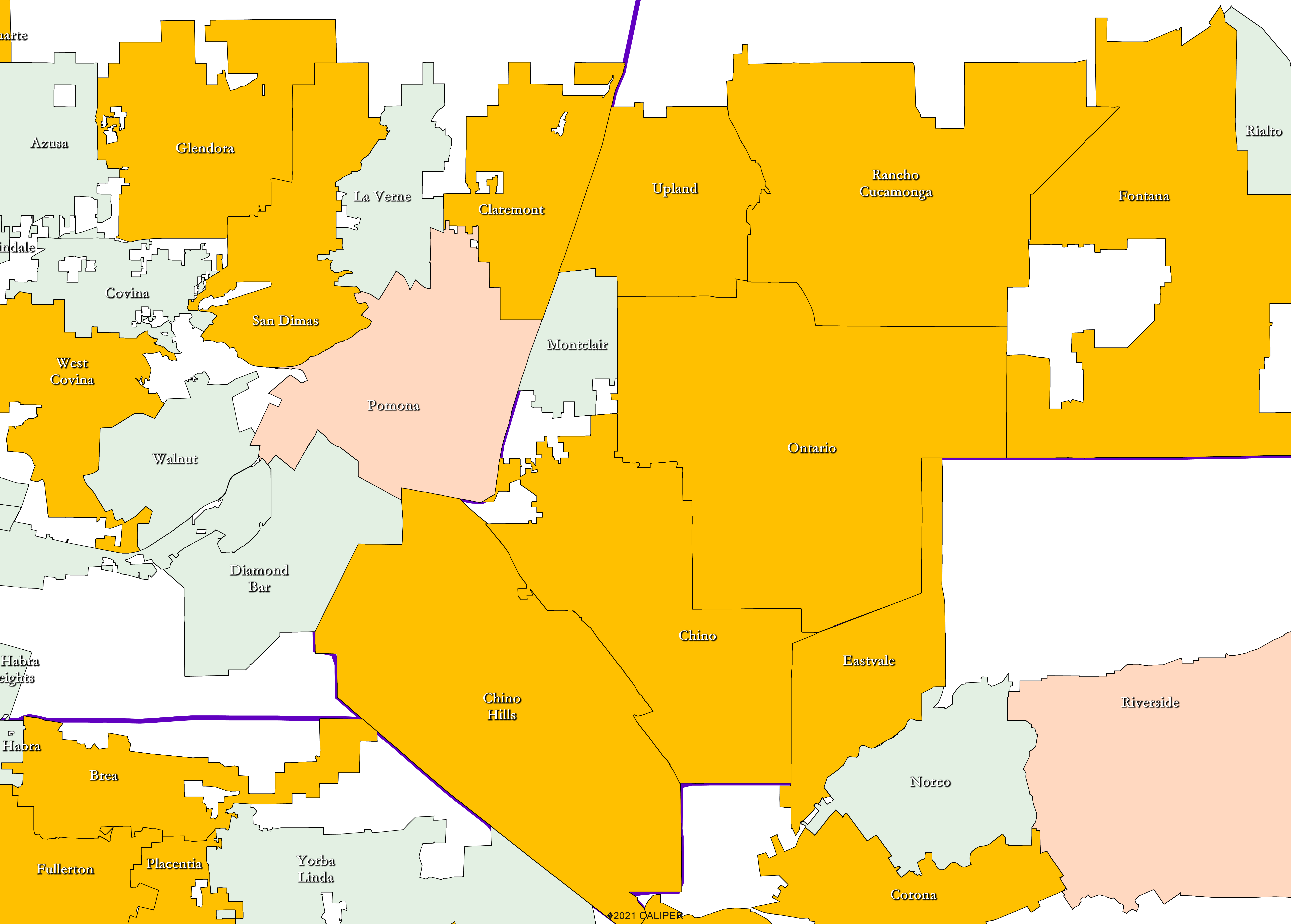
Since the California Voting Rights Act (CVRA) was passed, numerous Inland Valley cities have switched to a by-district system as indicated by the cities highlighted in gold in the map below (cities in light red were by-district before CVRA and cities in green have not yet gone to districts).
Currently, over 200 of the 482 cities in California elect their representatives through a by-district election system. For comparison, only 29 California cities held by-district elections prior to passage of the California Voting Rights Act. As of 2016, 65% of California cities have council-appointed mayors that rotate as opposed to directly elected mayors.
The La Verne City Council unanimously adopted Resolution No. 21-47 in July 2021, which initiated the districting process with the intent of creating five districts which would result in having a rotating mayor.
While not part of the resolution, the Council also discussed exploring a four-district system with a mayor elected at-large should members of the public submit maps and feedback using that type of system. Because of this, the City’s demographer, National Demographics Corporation (NDC), may explore the possibilities of both four districts with an elected at-large mayor as well as five districts with a rotating mayor through this process.
At the end of the mapping process, the City Council will make a final determination on which district map system will be adopted and whether to move forward with implementing new districts for the June 2022 election.
Districting determines which neighborhoods and communities are grouped together into a district for purposes of electing a Council Member. If the City Council decides to move forward in the process, the Council will seek input in selecting the first district-based election map. You have an opportunity to share with the City Council how you think district boundaries should be drawn to best represent your community either during the public hearings or by submitting comments via the contact page.
- Federal Laws
- Equal Population (based on total population of residents as determined by the most recent Federal decennial Census and adjusted by the State to reassign incarcerated persons to the last known place of residence)
- Federal Voting Rights Act
- No Racial Gerrymandering
- California Criteria for Cities (to the extent practicable and in the following order of priority)
- Geographically contiguous (areas that meet only at the points of adjoining corners are not contiguous. Areas that are separated by water and not connected by a bridge, tunnel, or ferry service are not contiguous.
- Undivided neighborhoods and “communities of interest” (Socio-economic geographic areas that should be kept together for purposes of its effective and fair representation)
- Easily identifiable boundaries
- Compact (Do not bypass one group of people to get to a more distant group of people)
- Prohibited: “Shall not favor or discriminate against a political party.”
- Other Traditional Districting Principles
- Respect voters’ choices / continuity in office
- Future population growth
A community of interest is a “contiguous population that shares common social and economic interests that should be included within a single district for purposes of its effective and fair representation.”
Below are useful excerpts from the Local Government Redistricting Toolkit by Asian Americans Advancing Justice – Asian Law Caucus (2020).
Communities of interest are the overlapping sets of neighborhoods, networks, and groups that share interests, views, cultures, histories, languages, and values and whose boundaries can be identified on a map.
The following elements help define communities of interest:
- shared interests in schools, housing, community safety, transit, health conditions, land use, environmental conditions, and/or other issues;
- common social and civic networks, including churches, mosques, temples, homeowner associations, and community centers, and shared use of community spaces, like parks and shopping centers;
- racial and ethnic compositions, cultural identities, and households that predominantly speak a language other than English;
- similar socio-economic status, including but not limited to income, home-ownership, and education levels;
- shared political boundary lines from other jurisdictions, such as school districts, community college districts, and water districts.
Share your specific thoughts, draw a map, or attend an upcoming public hearing to get involved!
- Submit written testimony about the process or a specific map via the contact page form.
- Click here to see the calendar of public hearings at which you can speak about the process or a specific map. At the hearings, we want you to:
- Share your story
- Define your neighborhood or community of interest
- Explain why districting is relevant to your community
- Get the tools you need to draw a map of one district or of all five districts
- Share your opinions of the draft maps
- Talk to your neighbors and local organizations
- Online and paper mapping tools will be available once the California-adjusted Census data is released in late September. The public can draw their community boundaries and submit them for consideration as the City’s final district map should the City Council decide to move forward with implementing by-district voting. Click here for information on drawing and submitting maps.
The process of districting requires the City to hold four public hearings: two prior to the release of draft maps and two after. Each public hearing will have a specific focus as tentatively outlined below.
Hearing #1 – August 30, 2021
- Introduction to the districting concept and process
Hearing #2 – September 27, 2021
- Educational presentation on La Verne’s path to districting
- Overview of mapping criteria and tools
- Soliciting public feedback on communities of interest
Hearing #3 – Date TBD
- Review of resident-submitted and demographer-created draft map options
- Discuss revisions and prioritize maps
- Consider potential election sequence
Hearing #4 – Date TBD
- Final map and election sequence selection
- Possible introduction of ordinance to adopt a by-district election system
To access public hearing information and materials, visit the Calendar page.
No, you do not need to submit a fully completed map. You can draw boundaries for only your neighborhood or only a portion of the city. It is helpful if you submit written commentary with your map describing why the particular neighborhood or area should be kept together in a single district.
Yes, you may submit more than one map. Please draw as many maps as you like. We suggest you submit only your top 2-3 preferred maps to assist the City Council in focusing on the map that best represents your community; however, there is no limit.
After you submit your map, the demographic consultants will generate the population and other demographic details for your proposed map. Maps can be viewed on the Draft Maps page or on the Interactive Review Map.
Once submitted, maps are considered public records.
The California Voting Rights Act (CVRA) was enacted by the State of California in 2001 to prohibit at-large election systems when it would hinder the ability of a protected class to elect candidates of its choice or otherwise influence the outcome of an election. The CVRA makes it significantly easier for plaintiffs to force jurisdictions into by-district election systems because it only requires two issues of analysis instead of the four required under the Federal Voting Rights Act of 1964:
- Does the protected class vote as a bloc?
- Do the voters who are not in the protected class vote in a bloc to defeat the preferred candidates of the protected class?
Common acronyms demographic categories:
- NH: Non-Hispanic
- VAP: Voting age population
- CVAP: Citizen Voting Age Population
- CVRA: California Voting Rights Act
- FAIR MAPS Act: Fair And Inclusive Redistricting for Municipalities and Political Subdivisions
- NDC: National Demographics Corporation (the firm hired to produce the maps and provide demographic data)
Online publications and guides to districting/redistricting:
A resident-sponsored ballot initiative would not delay or prevent the filing of a California Voting Rights Act (CVRA) letter/lawsuit by third parties who believe the City’s elections are not in compliance with the CVRA. If a CVRA letter is filed before the next election in June 2022, the City would be forced to undergo the districting process under a more condensed timeline to meet the law’s strict time frame, as well as potentially face less autonomy over how the district lines are formed.
Under a five-district system there would be five equally populated districts with a council-appointed rotating mayor. This would mean the five City Council Members pick one Council Member to serve as mayor for one year, after which the City Council picks a different Council Member to serve as mayor for another one-year term. Like the City’s current form of government under the municipal code, all five elected positions—four council members and a mayor—would possess the same voting power and collaborate to carry out policy direction.
The purpose of the California Voting Rights Act (CVRA) is to ensure that minority population groups are equally and fairly represented in its local government. By allowing La Verne’s Hispanic population to unite more strongly in one district as opposed to diluting or dividing them throughout multiple districts, their unique interests can be better represented on the City Council.
- If you drew a map using the paper tools, you can submit it by:
- Dropping off your map at City Hall (3660 D Street)
- Take a picture of your map or save it as a PDF, and submit it as an attachment on the contact page.
- If you used DistrictR,
- Be sure that you clicked “Save” instead of “Work in Progress” after drawing your map. You can either copy and save the URL and/or click the Share to Gallery button to be able to access and revise your map at a later date.
Residents are welcome to submit comments about their maps via the contact page. If you are submitting comments about a DistrictR map, be sure to identify the map number using the same label/ID that DistrictR provides. Paper maps with comments may also be submitted using the contact form, which accepts file submissions.
In order for draft district maps to legally be considered by the La Verne City Council at the final hearing on November 15, maps must be posted to the districting website by November 8. Since DistrictR is an online platform and draft maps are publicly available once submitted, the deadline for residents using this mapping tool has been extended to give residents additional time to draw maps. DistrictR maps can be worked on throughout the weekend and must be submitted by November 8 at 8 a.m. To allow the City’s demographer to process hand-drawn paper map submissions in time for them to be posted to the website by the legal deadline, paper maps must be submitted by this Friday, November 5. Residents are welcome to utilize both the paper mapping tool options and DistrictR to submit four or five district maps, as well as submit comments about their maps via the contact page.
Residents are welcome to utilize both the paper mapping tool options and DistrictR to draw and submit four or five-district maps. If the Council were to consider a four district system with a mayor elected at-large they will need to weigh the consequences of such a decision including the possibility that it could dilute certain communities of interest. Additionally, the original resolution unanimously adopted by the La Verne City Council which initiated the districting process was done so with the intent of creating five districts, resulting in a rotating mayor.